Having maintained this blog since 2016, given the experiences since then, it's reasonable to conclude that the Australian and State governments and some local governments only reinforce bushfire mythology, neglect their prevention responsibilities, fail to implement a full PPRR risk management approach to mitigating bushfire, shortcomings proven in the devastation of Wye River–Separation Creek on Christmas Day 2015 and Yarloop, WA, on 7 January 2016. And elsewhere since then.
Wildfire, with so much burning here in Australia and in the USA what does the future hold?
I started preparation of this blog during a period of relative calm a few days prior to the hellish fire situation in north-eastern New South Wales on Friday, 8 November 2019, but kept being distracted by a worsening fire situation.
Plate 1
1910 hrs Friday 8 November 2019
Plate 2
1313 hrs Saturday 9 November 2019
Following wildfires across the state of Victoria in 2009 that took 173 lives — how many other lives were shortened in the aftermath of the fires, an issue I'll delve into later — the government established the 2009 Victorian Bushfires Royal Commission to investigate the circumstances of those fires and make such recommendations as considered appropriate.
Protection of human life
Of the Commission’s 67 recommendations and other writings, to me the following quote stands out:
This reference to the protection of human life appears in several other places in the Commission's report and recommendations. The land use planning element of DELWP, and elsewhere in Victoria's emergency management literature there is reference to the "primacy of life".
Considering the loss of life and peoples homes and livelihoods in the current NSW and Queensland fires how is human life affected? I hear the emergency management agencies and governments congratulating themselves that there was no loss of life or it was minimised — "officially" those unfortunates who did lose their lives will probably carry the blame for their own demise i.e. they were warned.
The meaning of life
Surely there's more to it than simply saving their skins and what they stand up in. To me there is, which brings me to my heading, "Wildfire and the meaning of life."
A home is not simply a building; it is the shelter around the intimacy of a life. Coming in from the outside world and its rasp of force and usage, you relax and allow yourself to be who you are. The inner walls of a home are threaded with the textures of one's soul, a subtle weave of presences. If you could see your home through the lens of the soul, you would be surprised at the beauty concealed in the memory your home holds. When you enter some homes, you sense how the memories have seeped to the surface, infusing the aura of the place and deepening the tone of its presence. Where love has lived, a house still holds the warmth. Even the poorest home feels like a nest if love and tenderness dwell there.
The following three photographs are of the remains of a house in Wye River a victim of the 2015 Christmas Day fire. Noting the collectables still standing, love had obviously gone into the garden and no doubt its interior. Knowing a little about the owner it was certainly more than just another house, it was a home with lots of memories.
Plate 3
Plate 4
Plate 5
A few days ago I heard NSW Premier Berejiklian mention her concern for people traumatised by the fires including words to the effect that we should look out for them and help where we can. No wonder people are traumatised worring about their homes, animals and other things near and dear, and simply fear of wildfire itself.
Plate 6
2030 hrs Tuesday 12 November 2019
Finally, referring to my earlier question "how many other lives were shortened in the aftermath of the 2009 fires" I wonder what the longer term hidden cost will be with mental health issues or suicides out of the current NSW and Queensland fires.
Evacuation is the easy option, we can and must do better at protecting human life.
Note that the coloured text indicates links to further information to be clicked on.
The following placard was carried by one of the Gippsland protestors ‒ I wonder if she realises how widely that message applies.
A galvaniser of young people to involve themselves is Greta Thunberg, a Swedish student. You may be aware that Greta declined flying to the US, instead choosing to sail across the Atlantic to New York, asserting that air travel contributes to climate change.
I've been reading of politicians and emergency services leaders describing the recent fire activity in Queensland and New South Wales as "unprecedented". As to the accuracy of this description, to me that's no excuse.
Queensland in particular, why did the emergency management agencies not see this coming? Didn't they have people monitoring the drought factor; seek advice from the Bureau of Meteorology to learn of the potential for "unprecedented" extreme fire weather conditions based climate change?
Again, the question at the end of my 7 September posting, "How then to deal with the "new normal"? Clearly thinking outside the box is required to reduce environmental, social and economic loss from bushfire across Australia, but with their reliance on going it alone and water/fire retardant bombing is that a "bridge to far"?
We have nothing to be smug about in Victoria, the public land manager DELWP has little to be proud of in meeting its responsibility for fire management ‒ prevention and suppression ‒ in Gippsland last summer. What was the otherwise avoidable damage done to the environment as a result of those fires, including harmful products of combustion released into the atmosphere?
And, Minister Lily D'Ambrosio, who has multiple portfolios involved, has since received what some may consider is a hefty pay increase. So much for ministerial responsibility and accountability.
Finally, the Emergency Management Commissioner has some significant challenges if social, economic and environmental loss is to be substantially reduced in a climate increasingly conducive to the outbreak and spread of bushfire in Victoria.
Note that the coloured text indicates links to further information to be clicked on.
No doubt the social, economic and environmental losses accruing from these fires and fires yet to occur before the wildfire season or summer is over will be enormous and we've not yet seen the contribution Victoria is likely to add to the losses.
I continue to see governments and others claiming that climate change i.e. global warming is responsible for these fires, but not helping the broader community better prepare to withstand wildfire and its loss potential. By this I mean the forcing or encouraging people to leave their homes to agency firefighters and run the risk that they won't be defended due to lack of firefighters available for this task. I wonder how many of the homes lost will have succumbed to ember attack.
How then to deal with the "new normal"?
Note that the coloured text indicates links to further information to be clicked on.
Referring particularly to Victoria, though it's the situation elsewhere in Australia, loss is increasing daily with the current spate of fires.
While I could rant about the failure to bring lightning strikes under control much earlier, this story in today's The Age, is worthy of wide consideration, "We are not doing nearly enough to prevent the impacts of bushfire", by Kate Cotter, CEO Bushfire Building Council of Australia.
The failure by those responsible for the well-being of us and the natural environment includes the failure to manage fuel levels in our forests and parks, resulting in heavy fuel loads that are a major contributor to fire intensity and consequent suppression difficulty.
What are the root causes of theses losses? I've written about them in previous postings and they involve non-performing governments and their fire and emergency and land management agencies and local government. And then there's the firefighting industry: air attack to mention one beneficiary. And the insurance industry is worthy of a mention, too. But more about the insurance industry later.
When I posted the 23 November 2018 edition it was my intention to then look at a wildfire experience closer to home, the Christmas Day 2015 fire that engulfed a large part of Separation Creek and Wye River on the Otways coast.
To me, a major cause of property loss and associated loss of life in the California fires is a general lack of understanding of how fire crosses the land and mandatory evacuation orders. From what I've seen from the media and other videos I consider that the agencies are too response focused and need to involve the general public in active defence of their homes where the threat is ember or firebrand attack. What then are the lessons to be learned?
In recent times I’ve become aware of people who refer to the new normal or new abnormal and of course they’re referring to their perceptions climate change or global warming on wildfire. But we should consider the new normal or new abnormal is more than just climate change.
Plate 1
Graphic: The Australian, 22 January 2018
What's the graphic "Carnage Costs" have to do with wildfire?
On 22 January 2018 The Australian carried a story "Major city vigilance urged, with vehicle attacks the ‘new normal’
Causes me to wonder what the total suppression and recovery costs will be for Wye River‒Separation Creek. Could this money have been better spent on health and education in Victoria?
Preparing this posting during the afternoon of 7 December 2018 I listened to broadcast radio alerts to the communities in the Little River area concerning a wildfire — predominantly a grassfire albeit in stony country — with advice to the residents of Little River to evacuate.
From a story in The Age later in the afternoon "Little River fire: Blaze contained but homes still at risk"
Again the vexed question of evacuation, in this case an established township situated in open grasslands and having the benefit of a firebreak/control line in the form of a railway reserve aligned generally northeast southwest directly north of the closer settled part of the township.
Harking back to Dr Gordon's statement concerning the new normal, with global warming, be it short or long term its effect on the heavier fuels in our forests is a higher drought factor that leads to the heavier fuels more easily ignited and contributing to fire intensity that can in turn lead to pyrocumulus development above the fire.
Plate 2
Photo: Nicholson
Plate 2 shows pyrocumulus development above the Kilmore East fire. The photo was taken late afternoon on 7 February 2009 in Sunbury, which is approximately 50 kilometres west of where I estimate the location of the cloud. A lot of fuel is required to enable the development of a cloud of that size. Later into the evening it was producing lightning and light falls of rain towards its south-eastern end. Clearly a very hot fire.
Queensland fires spark federal inquiry
In a story in The Australian on 7 December 2018, concerning the recent wildfires in Queensland, Premier Annastacia Palaszczuk is quoted:
Climate change, Premier Palaszczuk? Begs the questions, what was your government doing to prepare for the effect of climate change? Were your government's agencies monitoring the increasing dryness of Queensland and modifying or adapting emergency management plans to take account of increasing vulnerability to wildfire? And what of preparing the people of Queensland? Nothing, I assume from the decision to evacuate 8,000 people from Gracemere to Rockhampton as one example.
It seems from the story that the federal parliamentary inquiry will have a relatively narrow focus:
Queenslanders, indeed all Australians deserve more and the inquiry should be expanded to consider the full gamut of factors that contributed to the fires and losses incurred, and the inquiry should not allow itself to be dominated by the emergency management agencies or their representatives. All wisdom concerning wildfire is not confined to the emergency services and the general public should be encouraged have input.
And again back to Dr Gordon's statement concerning the new normal.
With 50 firefighting vehicles reported as being committed to the Little River fire, where did they come from and were their home areas weakened in the event of other fires occurring? Would a trained and supported community have reduced the need to draw so many resources from other parts of Victoria?
Gracemere
Gracemere is a prime example of the need to seriously review wildfire management arrangements in Australia in today's environment.
Plate 3
Photo: Google Earth
Plate 3 is a Google Earth photo of Gracemere, Queensland. Take a stroll through and round the outskirts of the town using Google Earth Street View and determine for yourself its vulnerability to wildfire — comparable in size and surrounds with Hamilton or Horsham in Western Victoria and all surrounded predominantly by grassland.
Why then the decision to evacuate Gracemere?
Victoria fire model helped save Queensland town
From a story in The Australian, 29 November 2018, reasonably assumed to be from the Queensland Fire and Emergency Services:
Makes me wonder what the modelling actually predicted and who directed the evacuation.
The same questions could be asked concerning the advice to evacuate Little River Township.
This is what I wrote about in my last bushfire blog posting. How many homes, business, schools, etc, will be lost due there being no one there to extinguish embers as they begin to arrive, with homes, businesses and community infrastructure at risk far exceeding the availability of firefighting vehicles and firefighters to protect them?
In my blog posting SURVIVING BUSHFIRE, 26 October 2018, I mainly covered two issues:
• Lessons for Australia in recent fires in California
• Differences in wildfire fuel Victoria v California
In dealing with wildfire fuel I gave examples of how native trees in Victoria are involved in or respond to wildfire compared with trees in California.
Media coverage of the California fires in Australia is sure to unnerve many in our community and prompts the question, why are the fire management agencies not explaining the differences in fire behaviour due to the vegetation involved? Or does the media coverage serve to strengthen the "leave early" policy?
At this point I must stress that my criticisms are of fire and related emergency management policies, not firefighters who no doubt worked very hard and exposed to personal risk at times.
Out of the mouths of babes
There has been much criticism and mocking of US President Donald Trump for his comment about raking:
While raking the floor of the forest to remove the fine fuel is impractical, basically Trump is correct.
From the many graphic photographs and video clips posted by various media outlets it's quite apparent that extreme fire behaviour was occurring in the back country forests and being spurred along by chaparral and dry grassland. Add the effect of strong, dry Santa Ana wind notorious for driving wildfire in California and the result is fire behaviour shown in Plate 1.
What then of Mr Trump's raking the ground? Clearly, a failure to properly manage the wildland, regardless of who is responsible together with the effect of global warming, has led to the growing intensity of fires in recent years, which includes the loss of lives of 19 Granite Mountain Hotshots firefighters in Arizona in 2013.
But other factors leading to the life and property loss we are in witnessing in recent times includes a failure to educate communities at risk on what to actually expect and how to survive coupled with mandatory evacuation in the teeth of a fire.
While putting some at extreme risk, ordering people out also deprives the agency firefighters of the support of many with homes at risk, who with training and support from the firefighting agencies during the run of a fire could do much to reduce property loss and related loss of life.
Plate 2
Land Park, Redding, California.
Photo Axios 12 August 2018
And what of suppression and recovery costs compared to money needing to be spent on effective wildland management and township protection, I expect it would have been mind-numbing, particularly when the cost of air tankers are included.
Plate 3
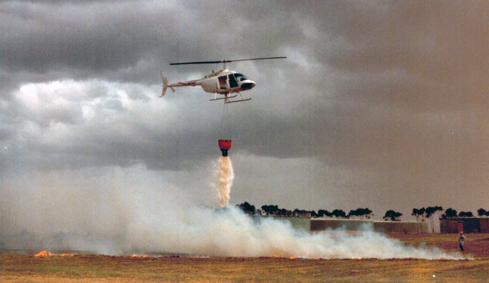
CFA trialing a Bambi bucket beneath its light observation helicopter in the mid-80s
Photo Nicholson
Plate 4
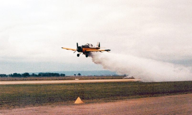
Dromader agricultural aircraft being demonstrated as a fire bomber in the early 80s.
Photo Nicholson
And on air tankers, I'm a supporter of helitankers (Plate 3) and small fixed wing agricultural aircraft (Plate 4) for their ability to be very precise with the delivery of their suppressant when compared with heavy fixed wing aircraft such as the B737 taken on in NSW for this summer wildfire season.
This extract speaks on the limitations of air attack:
An extract on cost-effectiveness from MEGAFIRE The Race to Extinguish a Deadly Epidemic of Flame, Michael Kodas, Houghton Mifflin Harcourt, Boston and New York, 2017, under the chapter heading The Fire-Industrial Complex:
Weldon [George Weldon, former deputy director of fire and aviation for the Forest Service's northern region] cited air tankers, which he helped manage when he was fighting fires, as an example of how industry drives wildfire policy. "The [US] Forest Service is looking at spending $500 million [USD] to get new-generation air tankers," he said. "But there's never been a scientific study that demonstrates the effectiveness of large air tankers. If a study was ever done, in my opinion, they are not worth the money at all."
Weldon and other retired Forest Service firefighters cited estimates that air tankers are effective only about 30 percent of the time. "It's a prime example of how powerful the fire-industrial complex has become in a very short time," he said.
Referring to that posting, "For those interested in cost-effectiveness, and governments should be, the Bushfire CRC report "EVALUATION OF THE EFFECTIVENESS OF THE 10 TANKER AIR CARRIER DC-10 AIR TANKER, VICTORIA 2010" should be food for serious consideration. Whilst it may look impressive to the gullible masses, could the money have been better spent on prevention over the years prior to the fire?"
Causes me to wonder, have we been seduced by the air tanker industry as they are not a panacea for preventing wildfire loss?
And on certain response comments to that blog posting, Karma at work?
The FOX 40 story is interesting, indeed inspiring as it shows how lay people with the support of a trained and experienced firefighter successfully defended a home:
Eventually, they ran into Paradise Fire Chief David Hawks.
"There’s a dog door here that one of the paramedics made access to it. We unlocked the garage, moved patients into this home and sheltered them in place," Hawks told FOX40.
What happened next was nothing short of amazing. Emergency medical technicians and nurses became stand-in firefighters, some getting on the roof of the home to clear gutters of brush sic [actually pine needles]. They hosed down the outer edge of the property.
They saved the home, all while their patients were kept safe inside.
"He said, 'You do this, you do this, you do this,'" Ferguson said. "All of us shifted our minds to what do we need to do for survival mode here."
"They followed directions," Hawks said. "They did exactly what I asked them to do."
Amid a neighborhood devastated by the Camp Fire, the Chloe Court home survived -- and so did all the patients and medical staff inside.
Listen to Chief Hawks in the video at the head of the FOX40 story (above) as he describes the action necessary to successfully defend that house, it's not rocket science.
Jamieson Creek fire rampaging towards the east on Christmas Day 2015 prior to the wind direction changing to push it into Wye River‒Separation Creek
Photo Stoios
Interesting the similarity between the scenes in Plate 1 and Plate 5. A fundamental difference between the two situations, the people under threat from the Camp Fire had a few short hours to take action compared with the people of Wye River-Separation Creek — it seems the Incident Controller had at least from 21 December 2015, four days, and that intelligence firmed up on 23 December, to organise the defence of those two communities with the participation of property owners prepared to assist. Why did this preparation not happen and it was left to well into Christmas Day before people were urged to leave?
Last Saturday, 27 October, I delivered a session at a Safe Healthy Summers Region Forum hosted by Nillumbik Shire Council, at Eltham:
Plate 1
First page from my PowerPoint presentation
The brief was to present my views on the recent wildfires (bushfires) that ravaged parts of California, USA; Algarve, Portugal; and around Athens, Greece and what we might learn from those fires.
In doing so I sought to mention a broader context of loss due to wildfire:
• human life
• pets and other domesticated animals
• family home
• sources of income e.g. tools of trade, farm animals, crops
• consequential effect on relationships in the family suffering loss
• consequential medical issues associated with suffering loss
Since Saturday while research wildfire information from the US I've added two more, important issues for another day:
• deleterious effect on the natural environment
• avoidable impost on the public purse
Recent fires in North America, Portugal and Greece … what lessons for Australia?
Having the benefit of spending time with forestry and fire agencies in Canada and the USA and being a long term student of fire behaviour and community responses generally I do have some understanding of wildfires and their impact in North America.
Concerning the fires in Algarve and Greece, in places the vegetation is similar to South-eastern Australia and the wildfire problem is similar to ours.
Currently we Victorians have the potential benefit of the following to mitigate wildfire loss:
• A “pecuniary interest” clause in the Country Fire Authority Act 1958 (CFA Act) that prevents people being forced to evacuate in the event wildfire does or may threaten their home;
• A provision in the CFA Act that enables the serving of “fire prevention notices” to abate fire hazards on private land;
• A provision in the CFA Act that places fire prevention or mitigation responsibilities on municipalities and public authorities;
• An Australian Standard for construction in wildfdire-prone areas: AS 3959; and
• CFA volunteer brigades embedded in much of the urban/rural interface and beyond enabling actual community involvement in emergency management.
Lessons for us?
The folly of widespread evacuation, be it voluntary or mandatory evacuation orders issued.
Plate 2
Land Park, Redding, California.
Photo Axios 12 August 2018
Plate 3
Swasey Drive, Redding, California.
Photo Axios 12 August 2018
Why folly? See what remains unburnt and not even scorched in Plates 2 and 3 and I’m referring to the vegetation.
The vegetation that remains undamaged is due to it being beyond flame contact and radiant heat sufficient to scorch that vegetation.
How wildfire travels across the landscape
Basically, fire travels across the landscape by igniting the fine fuel or vegetation such as dry grass, fallen dead leaves and twigs up to pencil size. Depending on the dryness of the heavier fuels such as dead-and-down tree limbs the fine fuel acts as “kindling” for the heavier fuels.
Nature of the fuel or vegetation in California compared with South-eastern Australia
The vegetation where the recent fires have occurred can be broadly described as grassland, chaparral and conifer forests i.e. pine and cypress trees.
Plate 4
An example of chaparral in California.
Photo: California Chaparral Institute
Plate 5
Chaparral fire in California.
Photo: East County Magazine, San Diego, California
Heath land in Victoria, such as that shown in the following two photographs, is similar to chaparral:
Plate 6
Heath at Anglesea, Victoria.
Photo: John Nicholson
Plate 7
Heath and low level scrub at Fairhaven, Victoria.
Photo: John Nicholson
Plate 8
Chaparral, cypress and pines in California.
Photo: FireScape, Arizona, USA
Plate 9
Mendocino Complex Fire in pines, California, USA.
Photo: Redhead Blackbelt, Northern California, USA
Plate 10
Young pine plantation near Harrietville, Victoria.
Photo: John Nicholson
Plate 10 is included to show the difference between pines and our native eucalypt trees. As shown in Plate 9 pines burn vigorously when ignited and like eucalypt species contain volatiles. However, unlike eucalypt canopies that tend to have significant gaps between the canopy and surface fine fuels or "kindling", pine and cypress tree canopies tend to be closer to the ground and compact compared to eucalypts.
Following are a series of photographs I've taken over the years following fires that have involved trees and shrubs in Victoria.
Plate 11
Photo: John Nicholson
Plate 11 is a view of Firth Park in the Lerderderg State Park a few days after the "Ash Wednesday 1983" fire showing an absence of "crown" or tree canopy fire in the forest in the background. Note the singed trees or shrubs in the foreground.
Plates 12 and 13 are further south from Firth Park towards Bacchus Marsh.
Plate 12
Photo: John Nicholson
Plate 13
Photo: John Nicholson
What is particularly significant about Plates 12 and 13 apart from the lack of crown fire? The unburnt shrubs/suckers at the base of the trees!
Below from my blog posting of 22 June 2014 are two examples of trees and shrubs in the path of the 9 February 2014 Gisborne fire as it travelled northeast towards Riddells Creek after the wind change.
The fire weather conditions this day were described as being the worst since 7 February 2009 (Black Saturday). Again, observe the vegetation close to the ground left unburnt when the fast moving grass fire passed.
Plate 14
Photo: John Nicholson
Plate 15
Photo: John Nicholson
Plate 15 is particularly significant in that cypress trees along the fence line were only scorched.
Plate 16
Skyline Road, Christmas Hills, post 7 January 2009
Photo: Bell
The arrow in Plate 16 points to a gap in the tree canopy that reveals undamaged eucalypt tree canopies in the background that were certainly in the path of the fire. Those eucalypts are on one of the higher points on the western side of Skyline Road.
Apart from heath and low scrub, the evidence is that crown fire is a relatively rare occurrence in the Victorian wildfire environment compared with how fire moves across the landscape in California. Unfortunately, the fires in California, Algarve and Greece featured large in Australian media and undoubtedly served to frighten lay people — counterproductive to building a wildfire resistant community.
Why then the loss of dwellings?
Plates 2 and 3 show unburnt vegetation around the remains of dwellings, and far more numerous than shown here. The unburnt vegetation tells us that consistent flames and radiant heat sufficient to ignite did not reach these dwellings.
The evidence suggests they were ignited by windborne embers from fire further distant. The reason for this ignition can vary, but one cause may have been embers landing on easily ignited bituminous roofing tiles preheated by the heat of the day plus hot air from the fire. Another cause may have been embers landing in vegetative mulch and igniting flammable vegetation close to windows, the glass eventually breaking and allowing fire to reach inside the dwelling.
This fire had also developed into what some may refer to as a "fire storm" with wind so strong as to damage the dwellings and allow ember penetration.
Plate 17
Land Park, Redding, California.
Photo: Google Earth 28 June 2016
Plate 17 is the current pre-fire photo of the land shown in Plate 2. There is nothing dramatic about the vegetation shown and if nothing had changed there was vegetation removal at the rear of the western side of the development and a much broader clearing to the north to inhibit flame contact and dangerous radiant heat reaching the dwellings.
The two yellow arrows point to backyard swimming pools that are points of reference for those who want to go exploring with Google Street View — views towards the west from further north along Buenaventura Boulevard show the vegetation involved.
How wildfire arrives
Windborne embers and firebrands are the major method of fire spread by igniting fresh fuel ahead of the main fire front. This process is known “spotting”, as in the lighting of “spot fires” or fires starting in separated spots ahead of the fire front. To be a threat, this burning material must be sufficiently light in weight to be carried by wind while continuing to flame or smoulder sufficiently long enough to ignite fresh fuel.
I categorise “spotting” as follows:
Embers
The transmission of light burning or smouldering material generally horizontally above ground out to a distance of 100 metres and usually in the form of burning dead eucalypt leaves and other material of a similar weight picked up off the ground, and possibly the larger forms of grass seed heads or burning stringybark from tree trunks.
Stringybark eucalypts, where the bark has not been given a recent “haircut” — singed by fire leaving the bark tight against the trunk with little or no fine fibres available to be ignited — will shed sparks and embers as fire travels up the bark. In strong wind stringybarks can be a prolific source of embers over a relatively short distance until all the fibrous aerated bark has been consumed.
Firebrands
Long distance spotting commonly involves the bark from gum species eucalypts, some of which shed their bark in the form of long ribbons that are susceptible to being carried aloft in the convection column or updraft above the fire. These ribbons of bark are generally aerodynamically shaped and consequently carry further in the upper wind. Due to their size they can remain alight for some time before falling to the ground and starting new fires, sometimes several kilometres downwind from the main fire. Plate 18 shows examples of gum bark ribbons.
Plate 18
Examples of gum bark indicated by the arrows.
Photo: John Nicholson
Wye River–Separation Creek, Christmas Day 2015
Plate 19
Wye River, Victoria, Christmas Day 201.
Photo: Stoios
Plate 19 shows spot fires burning under the influence of upslope in the absence of wind. The spots were due to gum bark firebrands further north following the break-out of the Jamieson Creek fire that occurred on 19 December 2015.
Plate 20
Wye River, Victoria, 11 February 2016
Photo: John Nicholson
Plate 20 shows the aftermath of the Christmas Day fire, with scorched tree canopies and virtually no true "crowning", but 116 houses lost in Wye River–Separation Creek. Plate 21 show the effect of the fire on vegetation on the high side of Karingal Drive where there were many houses lost.
Plate 21
Wye River, Victoria, 11 February 2016
Photo: John Nicholson
Why only scorching as shown in Plates 11, 12, 13, 14, 15, and 21? My opinion is that there was insufficient surface fine fuel or "kindling" under those trees and shrubs to provide sufficient heat to dry the foliage to the stage where it would actually burn.
Anglers Rest, Victoria, 2003
Here is an example of how fire crosses the land in an under-story fuel reduced environment. The video was recorded at Anglers Rest north of Omeo in January 2003 when the building was directly threatened — may take time to load but worth waiting. It shows some well prepared people protecting the building from fire in very windy conditions. The video shows fire moving past as "spot fires" that eventually join, but much of the fuel has been consumed by the time the "spots" join. Also note no "crowning".
Between 12 minutes and 17 minutes running time the podcast covers wildfire in California, USA, earlier this year and the believed impact of global warming, and note the comment "perpetual fire season" — some are referring to this as the "new normal".
Some photos and comments on the Carr fire here
3. Evacuation
What does this mean for Australia? Given the early onset of fires in Eastern Victoria this year it seriously questions the appropriateness of the one-size-fits-all leave early message if life loss is to be prevented and property loss minimised.
Photo: John Nicholson
Works in progress
There is more I would like to add, but this post is already too long. Consequently, I will follow this with another in the near future. Feel free to use the "following" facility in the side margin if you want to receive future posts.
Finally, please make your own inquiries about how much defensive space you need to have around your home or out-buildings, as individual circumstances vary according to slope aspect, vegetation type/s and the building's fire resistance capability. Also obtain CFA's literature dealing with bushfire survival, property preparation and leaving early.
References
While speaking about fire behavior I mentioned Bushfires in Australia, R.H. Luke and A.G. McArthur.
My copy is old: Department of Primary Industry,Forestry and Timber Bureau, CSIRO Division of Forest Research, AGPS, Canberra, 1978. It is still current and I consider it a preeminent textbook for those wanting to learn about wildfire in Australia. It should still be available somewhere.
Meantime, if you have a question or comment please use the facility at the foot of this posting.
Note that the coloured text indicates links to further information to be clicked on.
I have taken the liberty of using photographs that are not mine and have endeavoured to acknowledge the owners or copyright holders. The photos are used for educational purposes. If anyone is troubled by this please let me know via the comments facility at the bottom of this posting