Sunday, 21 February 2016

Obfuscation, sanitising, cabinet-in-confidence documents, burying, leaking — examples of some of the processes of government

It’s reasonable to expect that the Inspector–General for Emergency Management will have met the 19 February deadline and the Minister for Emergency Services the Honourable Jane Garrett will now have his report on the Wye River–Separation Creek fire.

The processes of government – how will the report be dealt with?

From my experience and I doubt that the processes have changed all that much, the responsible Minister will first seek the advice of others such as the Emergency Services Commissioner, CFA, DELWP and maybe Victoria Police. Actually how far down into these organisations advice will be sought is a moot point, given the early desire of the government to restrict investigation to an “internal process”.

Ministerial advisors will likely be asked for their advice and possibly government and media PR people. Another moot point, how many of these people will have the detailed knowledge to provide factual comment?

At what stage will the IGEM’s report be released to the public, will it be a sanitised version, etc? Might the government decide not to release the report, arguing that it is now a matter for the Coroner to consider, along with the advice received from the agencies?

Concerning the IGEM’s investigation, did he have any “riding instructions” from the Minister on what to investigate? Here, I’m reminded of the depth and detail of the terms of Reference of the 2009 Victorian Bushfires Royal Commission (click here).

What did the IGEM investigate and report on, only the question of “inaccessibility” of the lighting strike as justification for falling back to a fuel burnout to contain the lightning strike? Did he investigate the actual point/s of breakout and related circumstances of the origin of the fire on Christmas Day that went onto Wye River–Separation Creek?

Did the IGEM extend his investigation further to consider issues beyond the lightning strike and burnout that contributed to the loss at Wye River–Separation Creek? Issues such as the quantity of fuel in the forest between the burnout and those two communities?

Fuel reduction in the forest

This link shows that back in 2007 DSE recognised the importance of fuel reduction in the Otway parks and reserves (click here). It speaks for itself. Were any burns relevant to protection of Wye River–Separation Creek carried out during autumn 2007?

This link is to the DSE Otway District Approved Fire Operations Plan 2008/09 to 2010/11 (click here). Again, were these burns completed?

No doubt koalas and many other creatures of the forest would have died horribly or suffered terrible injuries as the fire ripped through the forest on its way south.

Did the IGEM form an opinion on the validity of any reasons given for DELWP failing to meet any of its fuel reduction burning plans important to Wye River–Separation Creek?

Township protection

Did the IGEM consider the effectiveness of the Wye River–Separation Creek township protection plan and its implementation — if there is such a plan — including the performance of the Colac Otway Shire Municipal Fire Prevention Officer and the CFA Chief Officer in utilising their hazard removal powers according to section 41 of the Country Fire Authority Act 1958? (click here)? The Chief Officer was given this power following a recommendation from the 2009 Victorian Bushfires Royal Commission:

Recommendation 54

The State amend the Country Fire Authority Act 1958 to enable the Chief Officer to delegate the power to issue fire prevention notices.

Section 41 fire prevention notices

Concerning issue of section 41 “fire prevention notices” did people from CFA head office who become involved in considering bushfire attack level exposure at BAL-FZ level according to Australian Standard AS 3959—2009 Construction of buildings in bushfire-prone areas visit Wye River–Separation Creek in the course of their duties? If yes, did they form any opinions on township protection and report any concerns they had to the CFA Chief Officer?

Did planning permit applications to erect dwellings inside the township boundaries that were rated at BAL–FZ arouse any concern in the CFA that something may be seriously wrong within the context of section 41(2)(a) Country Fire Authority Act 1958 regarding the vulnerability of existing buildings?

The following photograph is of the remains of a house on the north side of Dunoon Road, Wye River, lost to the fire.

Same house prior to the fire. A risk assessment based township protection plan should have identified building design and construction vulnerability to ember attack alone.

Photographed in September 2013 the vegetation generally below the houses on the north side of Dunoon Road, many of which were lost.

Prior to the current bushfire season did the Municipal Fire Prevention Officer or the CFA Chief Officer — in fairness to the current CO who has only been in that position for a relatively short time, I’m referring to his predecessor — address the vegetation hazard utilising section 41 Country Fire Authority Act 1958?

Did the IGEM inquire if Emergency Management Victoria had any concerns about township protection in the context of a total PPRR (prevention, preparedness, response and recovery) approach to the protection of life and property at Wye River–Separation Creek?

Remote area firefighting

Finally, concerning a determined, all stops out attack on the lighting strike fire while it was still small, Joint Standard Operating Procedure SOP JO2.06 (click here) specifies “Readiness Arrangements – Aviation Resources (Bushfire), which includes rappel and hover exit crews.

Under the heading Responsibilities:

Regional Controllers may request from the Emergency Management Commissioner (EMC) or State Response Controller (SRC), the relocation or variation of the of aviation resources.

Did the IGEM investigate why a hover exit/rappel crew was not deployed as "first responders" into what was considered an inaccessible area while the fire was still small?

counter for blogspot

Thursday, 18 February 2016

Poor or no quality control? Poor staff work? Replacing non-performers?

In my blog postings of 20 January (click here), 3 February (click here) and 14 February 2016 (click here) I’ve been testing the government line that the lightning strike that eventually went on to devastate parts of Wye River–Separation Creek occurred in inaccessible county and the fuel burnout to contain the lightning strike fire was not responsible for the Christmas Day fire.

The lightning strike occurred on 19 December 2015 and it was eventually decided to burn out the fuel around the inaccessible lightning strike on 22 December, at least two (2) full days following the strike.

There’s a contradiction somewhere in the government’s line on how the lightning strike fire was managed.

According to the Emergency Management Commissioner we’re told it was inaccessible (click here). However, Minister Neville in her 11 February Facebook posting praises DELWP’s remote area firefighters who are promoted as going anywhere — “Great to see our DELWP Firefighter Rapel [sic] Crews showcased on The Today Show!” (click here).

The CFA has acknowledged that “The original lightning strike was in inaccessible country and couldn't be ringed by dozers so it was then burnt out to Jamieson Track.” But why not move on from the bulldozer on foot and use hand tools to create a mineral earth control line and drag hose to extinguish the lightning strike while it was still small?

Begs the question, if Victoria has the remote area firefighting capability praised by the Minister, why was the lightning strike considered inaccessible?

AND WHAT OF QUALITY CONTROL?

Bushfire and war fighting

I have always equated fighting bushfires as similar to war fighting. Fire is clearly the enemy capable of lying doggo, storming across ground in strong wind, destroying property, if not watched closely may get behind and trap firefighters, producing lots of heat, smoke and noise, and killing and maiming.

With time limited before weather conditions worsened as they were predicted and did Christmas Day, how was the initially small fire being managed?

Knowing the capability of DELWP in controlling remote area lightning strikes in Gippsland, was anyone oversighting the performance of the Incident Management Team?

If the firefighting effort was proving unsuccessful, what was done to improve performance as the clock ticked down? Was the Incident Controller qualified for that role? Was the Incident Controller experienced in forest firefighting and able to understand the appropriateness and the likelihood of success of action plans recommended for implementation? Was the Incident Management Team upgraded at any time?

And on war fighting with fire as the enemy, I’m reminded of a situation on the north coast of Papua New Guinea in 1942 when the Australians were pushing the Japanese back from Kokoda.

An example of determined leadership involving Lieutenant General Robert L. Eichelberger, United States Army (click here):

“Eichelberger's fears were realized when the overconfident 32nd Infantry Division suffered a serious reverse in the Battle of Buna-Gona. Harding was confident that he could capture Buna "without too much difficulty", but poor staff work, inaccurate intelligence, inadequate training and, above all, Japanese resistance, frustrated the American efforts. The Americans found themselves confronted by a network of well-sited and expertly prepared Japanese positions, accessible only through a swamp. The Americans' failure damaged their relationship with the Australians and threatened to derail MacArthur's entire campaign. Eichelberger and a small party from I Corps headquarters were hurriedly flown up to Port Moresby in a pair of C-47 Dakotas on 30 November. MacArthur ordered Eichelberger to assume control of the battle at Buna. According to Byers and Eichelberger, MacArthur told him "in a grim voice":

"I'm putting you in command at Buna. Relieve Harding. I am sending you in, Bob, and I want you to remove all officers who won't fight. Relieve regimental and battalion commanders; if necessary, put sergeants in charge of battalions and corporals in charge of companies—anyone who will fight. Time is of the essence; the Japanese may land reinforcements any night."

General MacArthur strode down the breezy veranda again. He said he had reports that American soldiers were throwing away their weapons and running from the enemy. Then he stopped short and spoke with emphasis. He wanted no misunderstandings about my assignment.

"Bob," he said, "I want you to take Buna, or not come back alive." He paused a moment, and then, without looking at Byers, pointed a finger. "And that goes for your chief of staff, too."

I’m not suggesting that the firefighting ‘grunts’ on the fireline were slacking, but wondering, was the leadership up to the task? Did the leadership have full knowledge of all the resources available and have free access to them? Was their performance being critically monitored?

Which brings me to pose the questions, does DELWP have the necessary knowledge to efficiently and effectively manage major fires in the Otways, or is it subject to debilitating government interference?

While reference to MacArthur and Eichelberger may seem overly dramatic and I’m not suggesting a reckless approach, like the Japanese fire proved to be a rampaging and take-all-in-its-path enemy and should have been treated as such right from the outset when the lightning struck.

Did we have the necessary “killer spirit” to get on top of the fire while it was still small?

counter for blogspot

Sunday, 14 February 2016

Seeking the truth on the cause of the Wye River-Separation Creek bushfire

Since my 3 February posting “Food for thought on the cause of the Wye River–Separation Creek Christmas Day bushfire devastation” (click here), I’ve been provided with information on what I referred to as a time-lapse view of the fire area that was produced by Ripe Intelligence (click here)

The origin of the information in the video

The information came from the Vic Emergency web site (click here). At the date of this posting a plot of the fire area may still be available as part of the advice continuing to be posted on that fire.

Timing of the information

The fire spread sequence timings referred to as “time–lapse views” are shortly after the data to prepare the video was progressively taken up and posted by Ripe Intelligence. The perimeter data on the Vic Emergency web site does not include an observed date/time.

The time it appears on the Vic Emergency web site can be influenced by how busy the people responsible for the mapping are e.g. they may be dealing with more than one fire and mapping may be slow coming from the field.

Information on the spread of the Wye River–Separation Creek fire would have been critical to timely warnings to the community on Christmas Day. Consequently, I’m confident that times of the fire spreading shown in the video would have been close to real-time.

What the video shows

I’m informed that the video (click here) is published as an “impact area” rather than a fire perimeter given the limitations in the collection process, accuracy and intended use of the data. And, that generally, unburnt area is not depicted by agencies when initially publishing this type of information. It is added as detailed data becomes available and time allows.

Data behind the video

In my pursuit of the truth concerning where the Wye River–Separation Creek fire originated and the true meaning of “inaccessible” Ripe Intelligence provided additional data on the spread of this fire.

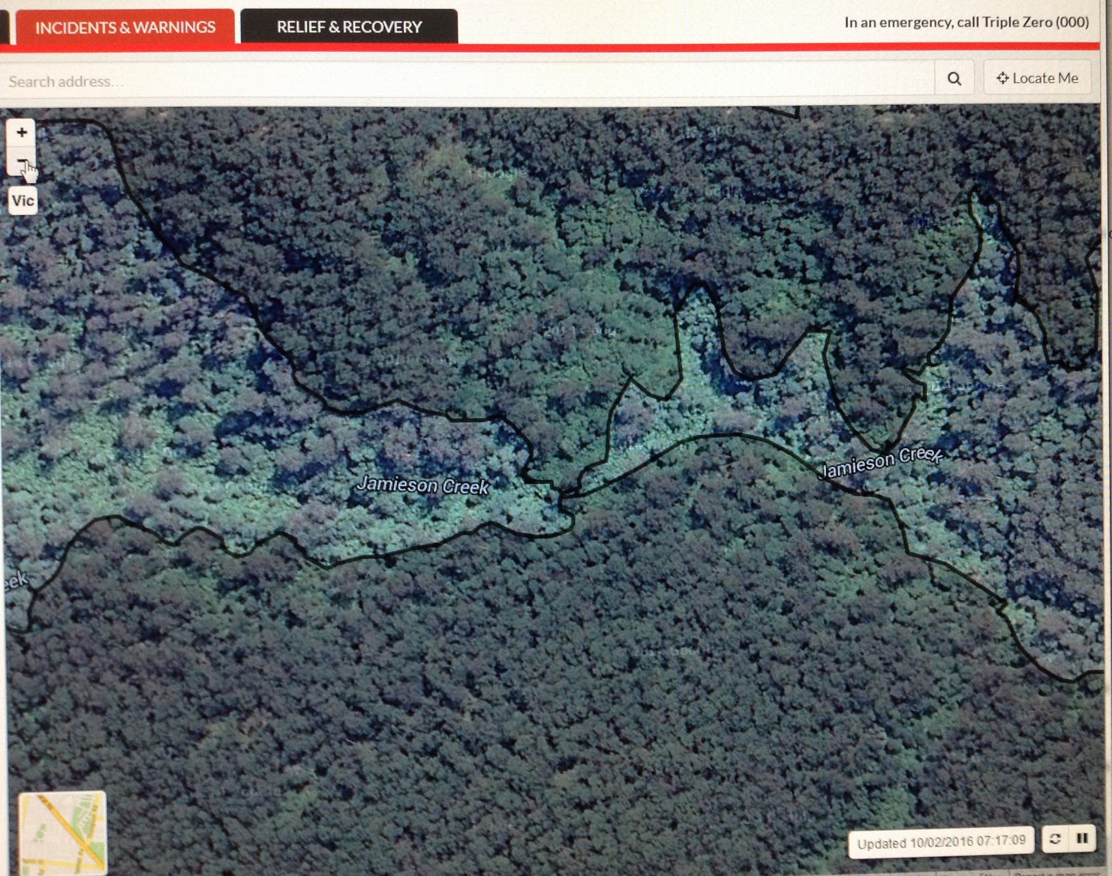
Below are the “time lapse” sequences overlaid on Google Earth. Here, my objective is to better show the fire caused by the lightning strike initially relatively small and clearly on the southern side of Jamieson Creek.

Comparing the terrain with the extract from Vicmap Topographic Map T7620-1-1-S (below), which is generally centred on Jamieson Creek in the area shown in the Google Earth extracts covering the vicinity of the lightning strike, I’m not convinced that any of that area is inaccessible to well-equipped, well trained, experienced and determined firefighters.

The arrow on the map points into the area more broadly shown in the video at 6:08 PM on 21 December.

The first three photos from Google Earth that match the sequences in the EmergencyAus video show the fire as not having crossed to the north side of Jamieson Creek:

6:08 PM 21 December 2015

12:44 PM 25 December 2015

4:04 PM 25 December 2015

4:38 PM 25 December 2015

Western end of the fire has started to move northwards.

8:38 PM 25 December 2015

Fire is on the steep upslope between Jamieson Creek and Cumberland Track.

3:48 AM 26 December 2015

Fire developing north of Jamieson Creek.

1:24 PM 26 December 2015

Fire continuing to develop north of Jamieson Creek. Could this have led to "lookout Lorne, here I come"?

With the benefit of more information

The following photos are from the Vic Emergency website on 10 February 2016 as an example of the agencies having had time to develop a detailed map of the total fire perimeter.

They are worth close examination to see the linkage between the fire areas north and south of Jamieson Creek. Having studied the information provided above I'm convinced the lightning strike was south of Jamieson Creek and in accessible terrain. Local knowledge suggests that the vegetation along the bottom of the gully would have been sufficiently damp to prevent the fire spreading to the north during the relatively mild days following the lightning strike.

It also seems reasonable to suggest that the northern control line for the fuel burnout was the damp fuel along the Jamieson Creek.

How then did the fire cross to the northern side of Jamieson Creek? Probably "spotting activity", possibly the approaching wind change starting to have an effect high up on the convection column, as Tolhurst opined on in work he did for the 2009 Victorian Bushfires Royal Commission: Report on the Physical Nature of the Victorian Fires occurring on 7th February 2009, final paragraph on page 6 (click here).

Where to from here?

A range of factors involved in initially controlling — or failing to control — the lightning strike to prevent the fire area growing to the extent where it broke out Christmas Day needs serious in-depth investigation.

And of course a key question:

Was the fire considered inaccessible if it could not be encircled by a bulldozer and tankers?

counter for blogspot

Wednesday, 3 February 2016

Food for thought on the cause of the Wye River–Separation Creek Christmas Day bushfire devastation.

From The Age story of 14 January 2016 (click here):

"That was a decision to make and what they call 'burning out', taking fuel out of the ground, that otherwise would have been in itself a bigger fire, a more intense fire, and something they couldn't control.

"The strategy was right. The wind got them on Christmas Day when it flicked embers up over the burnt area, over the mineral (bare) earth firebreak.

But Mr Lapsley said back-burning was not responsible for the devastation caused by the bushfire on December 25th.

"On my initial investigation, I don't believe the burning did contribute," he said.

"I think the larger areas that were burnt were to the east and west of where this fire spotted from.

"On face value, I believe the spot fires came from where the original fire was and it was the hottest, most difficult part of the fire," he [Mr Lapsley] said.

Following on from my blog posting addressing “inaccessibility” on 20 January 2016 (click here), I find it very difficult to accept that the lightning strike could not be controlled, if not completely extinguished at an early stage while the weather was relatively mild in the days prior to Christmas Day.

Maybe the EmergencyAus video included with The Age story dated 29 January 2016 provides useful information on the “inaccessibly” of the lightning strike (click here).

This video includes a time-lapse view of the fire area from 6:08 PM on 21 December through to 1:24 PM on 26 December 2015 (click here).

The first question I asked myself, is the video credible?

I first attempted my own “due diligence” on the video and its authors before accepting it at face value. I’ve also assumed it is credible as it was published by Fairfax, but that’s for others to judge, too.

If the video lacks credibility the government should explain why. Simply stating that it’s not credible without explanation is unacceptable in this the 21st Century. If the video is wrong, publicly releasing the fire management planning documents and maps up to the “breakaway" of the fire on Christmas Day would be helpful in supporting the government’s assertion on how the fire broke away from the containment lines.

In working through the time lapse sequences below, the The Age story should be closely analysed, too.

Time lapse analysis of the EmergencyAus video

6:08 PM 21 December 2015

The first sequence timed 6:08 PM 21 December shows the extent of the fire at that time, apparently still at the “uncontrolled” stage. And, on inaccessibility, the following extract from Google Earth based on the video shows the lightning strike and following fire as not moving north onto the steep upslope beyond Jamieson Creek.

The following extract from Vicmap Topographic Map T7620-1-1-S is generally centred on Jamieson Creek in the area shown in the Google Earth extract. The arrow points into the area more broadly shown in the video at 6:08 PM on 21 December.

From the Google Earth photo and the topographic map extract, does the terrain south of Jamieson Creek look all that inaccessible to trained, experienced and well-equipped DELWP firefighters?

According to a story in the Canberra Times (click here) on 30 January 2016, competent remote area firefighters exist in the ACT.

11:04 PM 21 December 2015

A thin line of fire is now shown along Jamieson Track, which I have taken to be the early stage of the fuel “burnout”.

North of the gully below Jamieson Track a thin line of fire is shown extending further west from the previous sequence. Was this part of the “burnout” and if so from a bulldozer constructed control line capable of use by tankers?

9:40 PM 24 December 2015

At Christmas Eve, the burnout is shown as having extended east to the Great Ocean Road and bounded by Jamieson Creek and Jamieson Track.

At its western end the burnout appears to have progressed no further north than the gully below Jamieson Track. Was this due to the vegetation in the gully generally being too damp to burn?

12:44 PM 25 December 2015

This sequence in the video shows fire across or south of Jamieson Track. Examination of the video on a large LED television screen gives a better view of what appears to be the path of fire leaving Jamieson Track, the general direction of which would have been consistent with wind direction and speed recorded nearby at the Aireys Inlet BOM recording station (click here).

What failed to hold the fire north of Jamieson Track, was it really the old lighting strike fire somehow breaching the burnout, was the burnout incomplete, did the lightning strike fire trickle through an incomplete burnout?

Given the very adverse weather conditions predicted for this day, were sufficient resources, including sufficient tankers and “boots on the ground” patrolling along Jamieson Track and large helicopter water bombers immediately available to rapidly support ground crews suppressing any “smokers” that popped up?

1:38 PM 25 December 2015

This sequence adds weight to fire across Jamieson Track, which appears not to join up with the burnout further to the east. This is consistent with my earlier comments on wind direction and velocity in the area.

2:14 PM 25 December 2015

This sequence appears to show the fire “thickening” at or near the head of the gully at the western end of the burnout from the area shown in the 9:40 PM 24 December sequence.

The vulnerability of the Great Ocean Road north of Wye River is also apparent, preventing use of that route for people evacuating from further south and firefighting vehicles approaching from the north.

Serious issues for risks managers with statutory fire prevention responsibilities to have considered in advanced planning for the protection of Wye River–Separation Creek, and the Great Ocean Road as an important “lifeline”.

2:58 PM 25 December 2015

This sequence appears to reveal a second breakaway further west of the earlier breakaway and considerably further west of the fire area shown in the 6:08 PM sequence.

4:04 PM 25 December 2015

This sequence shows reveals a dramatic increase in the size of the below the breakaway shown in the 2:58 PM sequence and sadly the rest is very costly history.

CONCLUSION

Statements attributed to Inspector-General for Emergency Management in The Age (click here) (click here) on 23 January 2016 on the burnout:

““The burn out strategy ahead of Christmas was "the most appropriate option available" and "there is no doubt in my mind that the eventual impacts on the Wye River and Separation Creek townships would have been far worse" had the fuel load between the main fire front and Jamieson Track not been significantly reduced prior to the spot fire occurring.”

Given the intensity of the fire and the property loss, I have difficulty conceiving of how the “eventual impacts on the Wye River and Separation Creek townships would have been far worse”. It was the development of the fire across public land between Jamieson Track and Wye River–Separation Creek, for which DELWP fuel reduction burning plans had not been implemented that influenced the intensity of the fire that eventually hit Wye River–Separation Creek.

There are a range of serious questions that need to be addressed about the cause of the Christmas Day fire and its subsequent development, if only to endeavour to assure Victorians that our bushfire emergency management arrangements and responsible senior managers are up to the task. In this posting I have raised some of those questions.

In this the 21st Century it’s no longer acceptable to conceal such matters within the bureaucracy of government and it's not consistent with the current mantra of “shared responsibility”.

blogspot hit counter

Wednesday, 20 January 2016

In this age of helicopters, when is inaccessible really inaccessible anywhere in Australia?

Since the Christmas Day fire that devastated parts of Wye River - Separation Creek, and continues to burn out of control deep in the Otway Ranges, I’ve listened to radio interviews of Emergency Management Commissioner Lapsley and read comments attributed to him that the lightning strike the cause of the fire was “inaccessible” because it was in a “gorge”.

The Macquarie Dictionary Third Edition defines “inaccessible” as not accessible; unapproachable. It goes on to describe “accessible” as 1. easy of access; approachable.  2. attainable.

I’ve thought long and hard about a lightning strike being “inaccessible” in the Otways.

The Department of Environment, Land, Water and Planning (DELWP) has a rappel crew in Gippsland that are considered to be remote and arduous area firefighting “hotshots”. Was the rappel crew amongst the options deployed to the lightning strike in its early days? A DSE video on the rappel crew (click here).

The Macquarie Dictionary defines a “gorge” as a “narrow cleft with steep, rocky walls, especially one through which a stream runs”. Does such a gorge exist where the lightning struck that precluded deploying a rappel crew to this particular strike?

If Victoria did not have the crews capable of this type of work, were they available elsewhere in Australia or New Zealand? I suspect they are available in NSW, Tasmania and New Zealand and certainly in British Columbia, Canada, where a crew could have been flown to Victoria virtually overnight for a fraction of the mounting suppression costs. BC Forest Service remote area firefighting capability video (click here).

In 1997 I was a member of an Australian and New Zealand forest fire managers group that went on a USA/Canada Fire Management Study Tour that included attending the 2nd International Wildland Fire Conference held in Vancouver. During the conference we attended Fire Expo 97, where wildfire equipment, services and technology were shown.

At the Expo I was impressed by horse or mule pack loads of remote area firefighting equipment. While not suggesting pack horses or mules for Victoria, such equipment could be lifted in by helicopter.

We also witnessed a Skycrane helitanker hovering while it attacked a fire through a mock up first floor window with a nose mounted water cannon. Do the Skycrane contracts with Australia include the cannons that may have been useful in directly targeting the lightning strike if it was really inaccessible to "boots on the ground"?

During a visit to a wildland fire agency in Canada we were shown examples of equipment it used, such as the portable dam, pumps and hoses.

The following video clip shows the use of a portable dam and hose laid cross country by NSW RFS volunteer firefighters to reach a fire inaccessible to tankers. Was this the problem at the lightning strike above Wye River-Separation Creek, it was inaccessible to tankers, but accessible to physically fit, well trained and properly equipped firefighters on foot? NSW RFS cross country hose lay video (click here).

As the firefight continues it seems we do have DELWP wildland firefighters capable of working in very steep country, as the screen shot from EMV shows. Question is, were those Victorians deployed to the lightning strike in the first few days or was it not until after Christmas Day they brought in their dry firefighting skills?

Having done some wildfire threat assessment work in the Otways, I can empathise a little with the firefighters shown above. At least I've had my feet in "boots on the ground" in similar terrain and vegetation. The following photos are typical of the "wet forest" and damp gullies of the Otway Ranges.

Given the widespread problems the fire has caused, plus the huge compensation and mounting suppression costs, these are serious questions for which only an independent public judicial can find factual answers. The Coroner is well-placed to conduct such an Inquiry unencumbered by political considerations.

Seems that Emergency Management Commissioner Lapsley may have been seriously misled in ultimately supporting the burnout of a larger area to make safe the lightning strike and Premier Andrews owes him and all Victorians an independent judicial inquiry to get to the truth of the catastrophe if we are to avoid another Wye River–Separation Creek.

blogspot hit counter

Friday, 8 January 2016

Time for some long overdue explanations and advice

As I finalise this posting Victoria’s emergency management agencies continue to battle a major fire in the Otway Ranges that devastated the Great Ocean Road (GOR) community of Wye River–Separation Creek on Christmas Day and wildfire all but razed the historic town of Yarloop (click here) in Western Australia.

Before going any further with the GOR fire and issues arising I will add some comments to my 23 December 2014 posting concerning the Bushfire Management Overlay (BMO) (click here).

Changes to the BMO introduced by then Planning Minister Matthew Guy, VC 109 that took effect on 31 July 2014, promoted as intended to make compliance with the BMO red tape easier, actually made it harder or financially prohibitive for some to achieve the required result, particularly where municipal councils or the public land manager — currently DELWP but probably subject to rejigging/renaming yet again in the future — don’t meet their statutory and moral responsibilities for township protection, thus driving the bushfire attack level category to BAL–FZ. I have examples of this, one of which contributed to the horror of the Christmas Day Wye River–Separation Creek fire.

A momentous and dubious change was the Minister’s decision to downgrade the CFA’s role in the BMO from the “determining referral authority” to a “recommending referral authority” in planning schemes for some development, notably erection of a dwelling.

Municipal councils are now responsible for determining the appropriateness of a BMO Bushfire Management Statement.

Where does that leave a council planner required to make the final decision and who has no real understanding of bushfire and is influenced by bushfire mythology?

Why the Minister chose to downgrade the role of the should-be-expert fire authority in the planning process, thereby adding to the difficulties and cost of obtaining a planning permit needs explanation.

“Leave and Live”

In earlier postings, I’ve been explaining actual bushfire behaviour to bring some balance to the one-size-fits-all mass evacuation mantra “Leave and Live” being parroted widely in Victoria. This only serves to frighten many people, particularly city folk, most of whom will then run at the first sign of smoke, regardless of the size and potential of the fire.

Mass evacuation only leads to unnecessarily vulnerable buildings and people fleeing at the last minute and adds questionable increased workload and possible personal health and safety threats to firefighters and other emergency services people, such as police. There’s much to be said for the adage “people save houses and houses save people”.

In a recent ABC News story, Bushfire and Natural Hazards CRC CEO Dr Richard Thornton (click here)  reminds us that many homes are lost as a result of being unattended when bushfire arrives:
Bushfire and Natural Hazards CRC's Richard Thornton suggested following the Ash Wednesday fires the main factor in whether a home was destroyed or not, was the presence of people.
He said while studies showed many people still were not adequately prepared for a bushfire emergency, it appeared as though more people were choosing to leave their homes when a fire struck — rather than stay and defend them.
"In general we are seeing an increase in number of houses lost but that is an inevitable consequence of people leaving early," Dr Thornton said.
"Clearly if you're not there when the fire gets there you're not at risk but it does place the houses at greater risk in that process as well."

Bushfire Building Council Australia

Kate Cotter, founder and CEO of the recently formed non-profit BBCA (click here) is also quoted in the ABC story:
"We know that over 92 per cent of houses are lost through ember attack in a bushfire so the science tells us what action we need to take and that's ember proofing," she said.
"So residents can use cheap commercial fire-stop products to fill in the gaps; fly-screens to protect windows, remove all combustible materials from the house, there's a lot of practical inexpensive ways to prepare property."
"We've got to really flip around our investment strategy in disaster resilience from one of suppression and recovery to prevention," Ms Cotter said.
"Every investment we put into risk mitigation saves the heartache and the property destruction and perhaps lives."

Horses for courses, while questioning the emotiveness of the word evacuation, in the case of Wye River–Separation Creek, I would not dispute that advice to the community based on the inadequacy of hazard reduction within and around perimeters of both settlements at the time of the fire and many people there holiday renters with no real thought for fire or equity in the houses they occupy. We need to think hard about the impact of that conditioning more broadly across the Victorian community, and across Australia, for that matter.

In addressing this extremely complicated issue, there needs to be a broader consideration of the meaning of “primacy of life” that came out of the 2009 Victoria Bushfires Royal Commission.

While being interviewed in the aftermath of the Wye River–Separation Creek Christmas Day fire, I heard Premier Andrews stress that we had no funerals to attend. So far correct, but I wonder about the longer term as emotional and financial difficulties start to bite people who’ve suffered severe loss.

The following photos from the fire in the Cobaw Ranges north of Lancefield late last year are very informative to the “Leave and Live” argument.

The first two are of a dwelling constructed to “alternative solutions” modified Level 3 category of bushfire according to AS 3959—1999 Construction of buildings in bushfire-prone areas component of a Wildfire Management Overlay Fire Protection Statement in September 2006.

With appropriate defensive space the assessment was that the threat to the building would be in the form of substantial ember attack and apart from a possible fleeting touch of burning eucalypt vapour, and I don’t believe that wind at dwelling level would be sufficiently strong for that due to the barrier or "drag" caused by forest trees, convective heat or “hot air”. That dwelling survived unattended and would have been suitable as a shelter if required by well-prepared people who understood the form in which fire would arrive.

The remaining three show the remains of a dwelling well removed from the forest, that given the greenness of its surroundings and it was likely unattended, succumbed to ember attack. The burnt shrubs against the remains of the dwelling were likely incinerated by the building fire. Provide it had been retrofitted to resist ember attack, people well prepared and understanding what they would face should have been able to protect this building.

I will do a further analysis of these two dwellings in a future posting.

For some an unwelcome Christmas present

Victorians, indeed all Australians, are being shortchanged by the current approach to bushfire management evident following the Great Ocean Road fire impacting Wye River-Separation Creek on Christmas Day. Seems I can now add Yarloop in Western Australia, as the all too familiar photo below from yesterday's edition of The Australian reminds me of the main street of Macedon in the aftermath of the 1983 Ash Wednesday Fire, which raises the question, what have we learned since Ash Wednesday? I think we've gone backwards.